|
+ 2008 + 2009 + 2010 + 2011 + 2012 + 2013 + 2014 + 2015 + 2016 + 2017 + 2018 + 2019 + 2020 + 2021 + 2022 + 2023 + 2024 1-2/2025 3-4/2025 5-6/2025 7-8/2025 9-10/2025 11-12/2025 + 2026 new HR EN |
1-2/2025 |
|
|||||||||||||||


| RIJEČ UREDNIŠTVA | ||
| Uredništvo HŠD-a | 3 | |
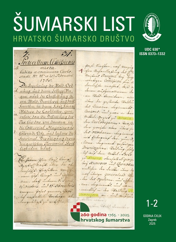
| 260 years of Croatian forestry (1765–2025) |  
|
|
| Croatian forestry was established on 23 February 1765. On that day, a committee meeting was held at the headquarters of the Karlovac Generalate of the Croatian Military Border in Karlovac, at which it was decided to appoint foresters and organize forestry service in three headquarters: in Baške Oštarije for the forests of the Lika regiment, in Krasno for the forests of the Otok regiment and part of the forests of the Ogulin regiment, and on Petrova gora for the remaining forests of the Ogulin regiment and the forests of the Slunj regiment. The head forester based in Baške Oštarije was assigned eight foresters. The head forester in Krasno, due to the larger area he had to manage, was assigned twelve foresters and one forester-hunter. The head forester on Petrova gora was assigned five foresters. The salary and place of residence were determined for each forester. A temporary instruction was drafted according to which foresters would work and teach their staff. This marked the establishment of our first three forest offices. At that time, during 1764 and 1765, in the same area, the first inspection, description and division of forests into districts were carried out. Thanks to a precise forest inventory, today we know that 42,017,128 trees of various tree species grew on 126,141 hectares, of which 27% were fir and 50% were beech compared to other tree species. The first original maps of the forests of the Lika, Otok and Ogulin regiments were created, which are today kept in the War Archives in Vienna. The second original copy of the map of the Lika regiment forests is kept in the Croatian State Archives in Zagreb. The period of the establishment of Croatian forestry ended in 1769 with the publication of the Forest Order of Maria Theresa. This was our first forest law, the first instruction for forest management and the first forestry textbook in the Croatian language. It prescribed cutting age (rotations) for the main tree species. Forest management was regulated by the method of dividing the forest area into annual cuts, the number of which corresponded to the number of rotation years. This way the principle of sustainability was introduced into Croatian forestry more than two and a half centuries ago, which only at the end of the 20th century became the backbone of global environmental policy under the name of sustainable development. The anniversary of 260 years of Croatian forestry is certainly an important part of the cultural heritage of Croatia. Croatian forestry should be proud of the fact that it is probably the only profession in our country that has a 260-yearold original document with the date of its establishment, an equally old original map of the forest area with a description of forests, and a 256-year-old law in the Croatian language on regulating sustainable forest management. Let us be proud of this and celebrate our anniversary in 2025. Editorial Board |
authors: Uredništvo HŠD-a | |
| IZVORNI ZNANSTVENI ČLANCI | ||
| Željko Španjol, Ivana Gašparović, Damir Barčić, Ana Šujica, Martina Obradović, Mario Ančić, Mihaela Jankavić, Sanja Stevanović, Boris Dorbić | https://doi.org/10.31298/sl.149.1-2.1 |
7 |
| Biological, ecological and spatial analysis of a monument of park architecture – Hellenbach castle park in Marija Bistrica |
|
|
| Parks are an integral part of the area around castles and are mainly protected as castle grounds by the Act on the Protection and Preservation of Cultural Property (Official Gazette 69/99; 151/03; 157/03; 87/09; 88/10; 61/11; 25/12; 136/12; 157/13; 152/14; 98/15; 44/17; 90/18; 32/20; 62/20; 117/21; 114/22) and the Law on Nature Protection (OG 80/13; 15/18; 14/19; 127/19) The park within Hellenbach castle in Marija Bistrica was the subject of this research due to its extremely high historical and cultural importance at the national level. This paper is based on the analysis of the inventory of the dendrological species of Hellenbach park over the past forty years (inventories carried out in 1978, 2007, 2011 and 2021) and the changes that have occurred in terms of the presence of species and their shares over time. The last inventory, in the form of field work, measurement and data collection, was carried out by the authors of the paper in May 2021. All trees and bushes were measured, and the collected data was used to compare the current condition with the previous condition. The results of the analysis were used to define measures for the restoration and preservation of the park around the castle in the future. On this basis, the main guideline for landscaping the park, based on inventory, analysis and future use, is a combination of revitalization and conservation of the castle along with the park. Field measurements in this research determined that the health condition of the park is satisfactory, but that the restoration of the parks dendroflora is necessary. After the preparation of expert guidelines, the authors propose the expansion of the protected area of the park as a monument of park architecture on the entire area of 5.5 ha according to the Law on Nature Protection (OG 80/13; 15/18; 14/19; 127/19). The protection of the entire area of the historical park enables its full functional evaluation (its history, landscape, and usage), more active protection and maintenance. The management of castles and parks could be carried out through a management plan based on income from visitors, which would be an integral part of modern cultural tourism in Hrvatsko zagorje region. |
authors: Željko Španjol ŠL Ivana Gašparović Damir Barčić ŠL Ana Šujica Martina Obradović Mario Ančić Mihaela Jankavić ŠL Sanja Stevanović Boris Dorbić | |
| Esmera Kajtaz, Dženita Alibegić, Haris Nikšić, Željko Španjol, Boris Dorbić | https://doi.org/10.31298/sl.149.1-2.2 |
25 |
| Variations in the total phenolic content and antioxidant activity of fresh houseleek leaves (Sempervivum tectorum L.) with regard to provenances from urban and rural environments : the area of Mostar, Bosnia and Herzegovina |
|
|
| This research aimed to determine the antioxidant activity and total phenolic content of fresh leaves of Sempervivum tectorum concerning provenances from urban and rural environments. Fresh leaves of the houseleek plant material were collected on a sunny day in June 2024. The homogenized sample was then subjected to maceration extraction at room temperature using distilled water and aqueous solutions of 70% and 50% ethanol and 70% and 50% methanol. The total phenolic content was determined by the Folin-Ciocalteu method, and the antioxidant activity was evaluated by the DPPH scavenging method and expressed using the Trolox standard as an equivalent (µmol TE/g). Total phenolic content ranged from 42.91 ± 0.83 to 115.96 ± 0.48 mg GAE/g, depending on the type of solvent used and the origin of the plant material. The highest values of antioxidant activity had the methanol extract with a value of 672.51 ± 2.47 µmol TE/g, and the lowest values had aqueous extracts of plant material of both origins. The houseleek samples from higher altitudes showed exceptional antioxidant activity with values from 672.51 ± 2.47 to 359.79 ± 3.97 µmol TE/g, while the samples collected at lower altitudes showed a lower ability to remove radicals according to the DPPH method with values from 366.86 ± 6.91 to 232.78 ± 4.55 µmol TE/g. Using multiple linear regression, it was shown that provenance (ß = -0.64; t = -3.167; 0.0016 < 0.05) and solvent (ß = 0.552; t = 2.734; 0.029 < 0.05) are significant predictors of the total phenolic content for the analyzed samples. Provenance (ß = 0.78; t = 4.55; 0.003 < 0.05) and solvent (ß = -0.422; t = 2.445; 0.044 < 0.05) are also significant predictors for the antioxidant activity results of the analyzed samples. The result of the t-test showed that there is a statistically significant difference (0.013 < 0.050) in antioxidant activity regarding the provenance of the plant material (urban/rural). |
authors: Esmera Kajtaz Dženita Alibegić Haris Nikšić Željko Španjol ŠL Boris Dorbić | |
| Biljana M. Nikolić, Jelena Božović, Dalibor Ballian, Saša Eremija, Zorica S. Mitić, Marija S. Marković, Nevena Čule | https://doi.org/10.31298/sl.149.1-2.3 |
35 |
| Microelements variability in needles of natural populations of Picea omorika |
|
|
| This is the first study of microelement variability in needles of seven natural populations of Picea omorika (Panč.) Purkyně from Serbia. Seven essential, three usefull, and six toxic microelements were analysed by ICP-Spectrometer. Their range was as follows: Mn > Fe > Zn > Al > Na > B > Cu > Ni > Cr > Cd > Co. The microelements Mo, As, Hg, Pb and Se were detected in traces. The amounts of Al, B, Co, Cr and Na were recorded in P. omorika needles for the first time. Among usefull microelements the most abundant was Al, while among toxic it was Cr. The most southern population, Mileševka canyon, had the highest amounts of Zn, Cu, Ni, Co and Cd and the lowest values of B. Discriminant and cluster analyses visualized that this population also showed the greatest separation from all other populations. Further research could usefully explore factors that affect the endangerment of P. omorika in its natural habitats or prevent its natural regeneration. |
authors: Biljana M. Nikolić Jelena Božović Dalibor Ballian Saša Eremija Zorica S. Mitić Marija S. Marković Nevena Čule | |
| Zümrüt Kurtulgu, Atinç Pirti | https://doi.org/10.31298/sl.149.1-2.4 |
45 |
| A new approach for the classification of ground points from airborne LiDAR data in forested areas |
|
|
| LiDAR systems are being used increasingly widely and effectively in the field of forestry. They play an important role in many applications such as creating detailed maps of forests, obtaining high-precision elevation data, obtaining information about the height, density and distribution of trees, mapping the topography under the forest in detail, landslide and erosion control, road planning and water management. Underforest topography maps can be created with high precision thanks to LiDAR ground points. In our study, we present a new approach by using LiDAR data to create the physical characteristics of forest land. In this approach, firstly, airborne LiDAR beams were divided into datasets according returns. Three datasets were created: second return, last return and first/last return. Secondly, each dataset was positionally placed in the grid structure. Filtering was done according to mean height values of points in the cell. Thirdly, DBSCAN clustering algorithm, one of the machine learning methods, was used. The epsilon value, one of the parameters used in the DBSCAN algorithm, was determined according to the silhouette index, and LiDAR ground points were classified. The classified LiDAR ground points were compared with the existing ground control points. As a result, the combination of the second return and the last return dataset showed successful results with a kappa value of 82.27% and an F1 score value of 0.71. Also, digital terrain models were created and compared. To demonstrate the effectiveness of the proposed approach, data was compared with the CSF algorithm, which is one of the traditional filtering methods. After the accuracy evaluations, we were able to classify more LiDAR ground points with our proposed approach. Thus, we think that LiDAR ground data can create a detailed and accurate topography map, define forest features and contribute to the decision-making process for forestry activities. |
authors: Zümrüt Kurtulgu Atinç Pirti | |
| Özdemir Şentürk, Mehmet Güvenç Negiz, Serkan Gülsoy | https://doi.org/10.31298/sl.149.1-2.5 |
57 |
| Hierarchical model-based ecological classification and mapping of Gölhisar district |
|
|
| In the study, a hierarchical model-based ecological land classification and mapping were carried out in Gölhisar district with vegetation groups. The presence-absence data of woody plant species were recorded in 398 sample areas in the district. In the study, elevation, slope, aspect, radiation index, topographic position index and bedrock variables required for model-based classification and mapping processes were created. In the statistical evaluation process, firstly, distinction groups were formed by clustering analysis, and then model groups were formed by classification tree techniques. The Chi-square test was applied to determine the relationship between the sub-sampling areas in the groups obtained from clustering analysis and the sub-sampling areas in the model groups obtained from the classification tree technique. As a result of these procedures, a total of four different vegetation groups were obtained in the district by adhering to the hierarchical distinction principle. In the last stage, the regionalization process was carried out by using the variables structuring the tree model in the classification tree technique, and thus the tree model obtained was mapped. As a result of this study, Gölhisar district was divided into four different vegetation groups. Based on this hierarchical vegetation classification, the most important variables were determined which include elevation, radiation index, topographic position index, and bedrock types in the district. While the first and second groups of the separated vegetation groups correspond to the upper parts of Eu-Mediterranean and supra-Mediterranean climate zones, it is possible to say that the third and the fourth groups correspond to the mountainous (above 1200 – 1300 m) and oro-Mediterranean climate zone. |
authors: Özdemir Şentürk Mehmet Güvenç Negiz Serkan Gülsoy | |
| PREGLEDNI ČLANCI | ||
| Ana Romana Armanda, Mario Bjeliš | https://doi.org/10.31298/sl.149.1-2.6 |
67 |
| Overview of invasion and control management options of Cydalima perspectalis (Lepidoptera, Crambidae) |
|
|
| Box tree moth, Cydalima perspectalis, originally from East Asia, has invaded 40 countries in Europe and the Middle East, as well as two countries in North America. The exact pathway of invasion is uncertain, but it is believed to have reached Europe and the United States through multiple introductions by import of boxwood plants, followed by further spread due to biological characteristics of the species, climatic conditions and the wide distribution of the host plant. This review aims to provide an overview of the highly invasive C. perspectalis and identify perspectives for its effective control and management. Possible control methods include insecticides and environmentally friendly options such as entomopathogenic bacterial strains, fungi, nematodes, plant insecticides, and mating disruption. An integrated pest management is crucial for C. perspectalis control. Detection methods, prevention strategies, monitoring of pest and damage, assessing overwintering capacity, and developing effective control measures are key future perspectives. Through research, collaboration, and strategic interventions, it is possible to mitigate the impact of C. perspectalis and protect vulnerable ecosystems from the devastating consequences of this invasive pest. |
authors: Ana Romana Armanda Mario Bjeliš | |
| STRUČNI ČLANCI | ||
| Damir Miškulin, Nives Salopek, Dalibor Babić, Matea Vuković, Tihana Otmačić | https://doi.org/10.31298/sl.149.1-2.7 |
77 |
| Analysis of the success rate of rehabilitation of windthrows in state forests in the Medvednica nature park |
|
|
| Due to its location, in the immediate vicinity of the capital, Medvednica receives a great deal of attention from citizens. In addition to the ecological and socio-ecological functions, the social functions of forests also come to the fore: touristic, recreational, health and aesthetic. Within the Medvednica Nature Park, much of the public’s attention is focused on forest management, and numerous inquiries are related to the biological restoration of forests, which includes the removal of trees. Only the sustainable way of management that we carry out makes it possible to maintain the optimal state of forest ecosystems to follow the demands of nature, which daily requires of us to understand natural processes and changes. In the last 12 years, the forests in the Medvednica Nature Park have suffered several major storms and several smaller ones, which left a significant mark on the landscape of this area, damaged the structure and stability of the stands, and changed the forest management plans of this area. Hrvatske šume d.o.o. (Croatian Forests Ltd), which manages the state forests of Medvednica, has made extraordinary efforts in all phases of the restoration of the windthrows and to ensure the continuation of further sustainable management. Remediation of windthrows can be divided into three phases: 1. urgent interventions on public infrastructure, 2. measurement and export of timber with the establishment of forest order, 3. biological restoration of forests. The purpose of the paper is to obtain a description of the rehabilitation works carried out to serve as an example of good practice in the circumstances of climatic extremes. The aim of this paper is to show the amount of wood mass rehabilitated in the last 12 years and to point out the importance of continuous management for the stability of the forests on Medvednica to try to reduce the impact of climate change. We will also show how the restoration of windthrows affected the planned management prescribed by the Forestry Economic Plan, and how the uncontrolled dispersion of wood mass due to the wind affects the very appearance of Medvednica, thus requiring dangerous and expensive rehabilitation procedures. As a result, great effort and resources are invested in informing the public about all forest works around Medvednica, and efforts are made to approach the principles of the forestry profession and point out the purpose of organized forest management to establish trust between the public and the forestry profession. |
authors: Damir Miškulin ŠL Nives Salopek ŠL Dalibor Babić ŠL Matea Vuković Tihana Otmačić | |